Welcome to Høgruta i Jotunheimen

77 km – 7.208 vertical meters

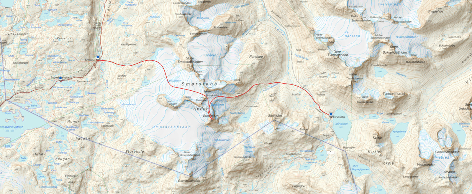
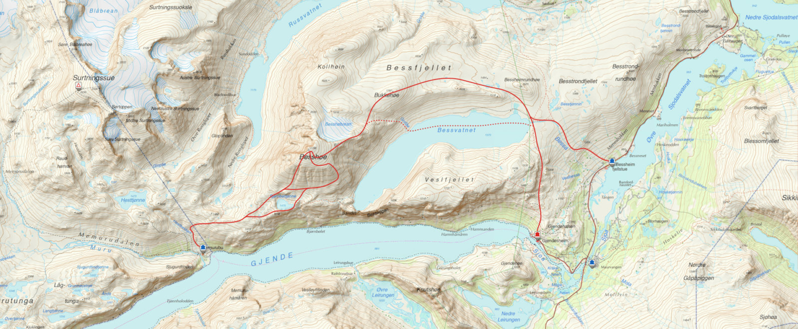
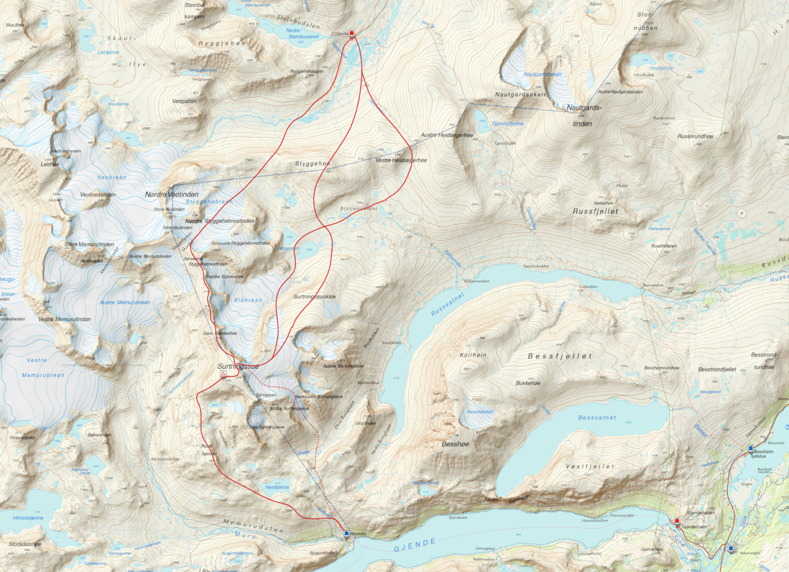
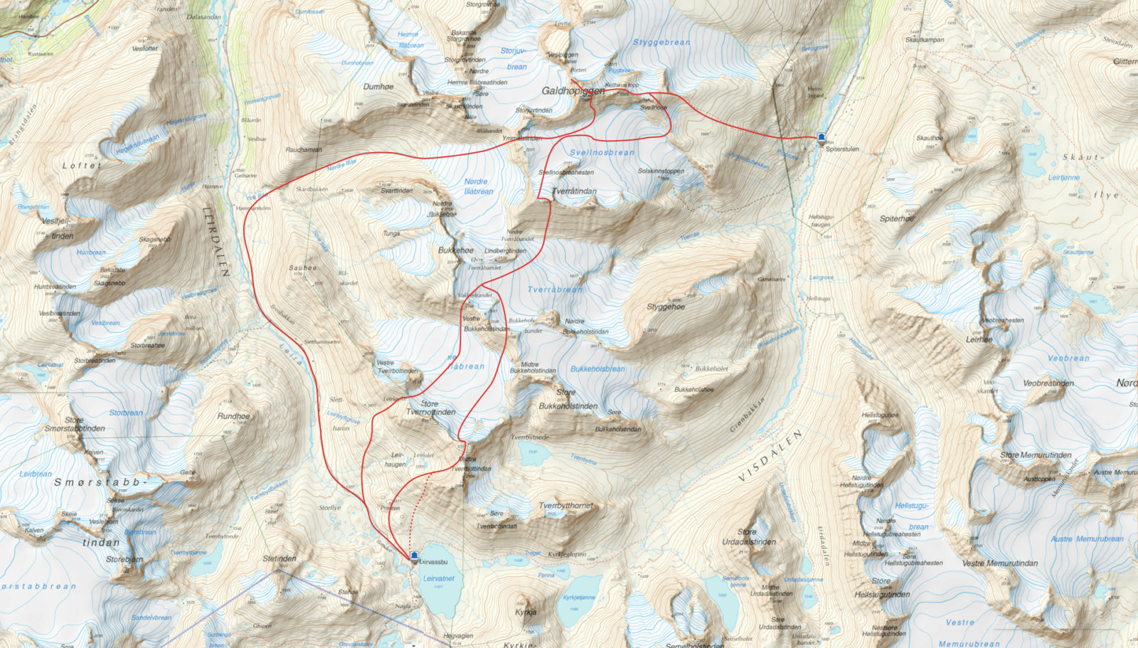
Jotunheimen Haute Route is a five-day randonée ski tour into the heart of Jotunheimen National Park. The route crosses at least eight glaciers and seven 2000-meter summits, including the mountains Glittertind and Galdhøpiggen. Overnight accommodation is at staffed lodges. Each leg is approx. 15 km, with 1000-1500-meter elevation gain.

It took climbing North Africa's highest mountain for Johan Wildhagen and Stian Hagen to realise that the ideal randonée skiing destination was in fact located in the Norwegian mountain range where they holidayed as children.

There is some truth to this. You need to leave to discover what you have back home. Playwright Henrik Ibsen had to travel to Italy to write his greatest plays about Norway. For Stian Hagen and Johan Wildhagen, something happened in North Africa in 2012.

They brought their ski gear to another continent, landed in Marrakesh, drove for hours, and then walked for hours in a throng of people, who were all going to the same place. People make the journey here from round the world. Norwegians Stian Hagen, a randonée-skiing pioneer, known for having climbed almost all of the Matterhorn and skied down, and travel companion and photographer Johan Wildhagen, known for assignments in the roughest landscapes, left Scandinavia to ski down North Africa's highest mountain: Toubkal.

It could have been bliss. It could have been everything they had dreamt it would be.

What are we doing here? they started thinking. What are we doing? That is when they got the idea.

- Jotunheimen, said buddy Stian Hagen.

- We need to go home to Jotunheimen. Norway's Haute Route is there, waiting for us.

They had known the Norwegian mountain range all their lives. It was so familiar to them that it became invisible. But now it was revealed to them. Jotunheimen's impressive and relatively untouched peaks were clearly a randonée-skiing destination. The invisible became visible. They put on their skis and created Jotunheimen Haute Route.

Day #1

Gjendesheim > Memurubu

16 Km – 1258 Vertical meters
Open map on ut.no Route selection must be varied according to weather and lead

Our route suggestion is to start from Gjendesheim lodge/Bessheim lodge and go westward, through the heart of Jotunheimen. Summit some of Norway's iconic peaks on route to the west side of the national park. The trip takes six days. It includes five overnight stays at mountain lodges and ascending at least six or seven 2000-meter summits, including Glittertind and Galdhøpiggen. Each day consists of approx. 15 km of trekking and 1000 and 1500 meter elevation gain. It is similar to the daily legs of the original Haute Route, but the advantage in Jotunheimen is that the relatively low elevation above sea level makes it considerably easier than in the Alps. In case of bad weather, it is also always possible to follow a shortened route to the next lodge. This is in contrast to the original Haute Route, where it is common to be impeded by bad weather, and you need to be lucky with weather and snow conditions to be able to complete the entire trip.

1

1:Stian points to the bridge we have to cross on our way up to Besshø mountain.

On day 1, the route follows the marked winter trail from Gjendesheim lodge or Bessheim lodge to the east end of Bessvatn lake. If you walk from Bessheim lodge, you are walking directly westward and the sun is therefore not too fierce. During Easter, when the sun is blazing in the mountains, this can actually be an advantage. From Bessvatn lake, you follow the ridge up to Bukkehø mountain and onward to the summit of Besshø (2258 meters above sea level). It is a pleasant trip going up with a gradual and manageable ascent. Besshø is an impressive mountain, a transition between the gentle mountain formations in the east and their more alpine, jagged counterparts on the north and west side. The view is incredible. Facing south, the view overlooks the region of Valdres and Gudrandsdalen valley. One of the most beautiful views from a summit on this side. You stand above Besseggen ridge, looking down on the Bessevatn and Gjende lakes. And you see your route onward.

Gjendesheim lodge: Located near one of the most important gateways to the eastern part of Jotunheimen. Gjendesheim has 185 beds, distributed across 1, 2 and 4-bed rooms with dormitories in a separate house. On the menu is local food based on local ingredients, local food traditions or food delivered from local suppliers.

Opening dates 2024
Winter season: 17 February – 1 May

Read more about Gjendesheim here


1
2

1:David Rosenbarger in yellow. Behind him is Stian, followed by Dag Inge Bakke, Christina Lusti and all the way at the back: Andrea Binning, Stian's wife.2:David Rosenbarger in yellow. Behind him is Stian, followed by Dag Inge Bakke, Christina Lusti and all the way at the back: Andrea Binning, Stian's wife.

The descent is made down the west couloir, alternatively the west ridge if there is an avalanche risk. The west couloir starts out rough and steep. The alternative is to walk down the ridge and enter the couloir at a lower point. From there, you follow the natural ridge to Memurubu lodge. If the weather is bad, you can go directly over Gjende lake to Memurubu, following a marked trail.

Bessheim lodge: Located east in Jotunheimen, near national road 51 over the Valdresflye mountain plateau. The lodge has a total 150 beds and is staffed from the middle of February. Bessheim also has 27 rooms inside the lodge with made beds and most rooms include an en-suite bathroom with a shower and toilet.

Opening dates 2024
Winter season: 9 February – cirka 17 May

Read more about Bessheim here

1

1:Dave on his way down from Bessø mountain. We drive along the south side. In the distance is Gjende lake, covered in ice and snow.

Day #2

Memurubu > Glitterheim

18 Km – 1400 Vertical meters
Open map on ut.no Route selection must be varied according to weather and lead

The route follows the summer route over Raudhamarn to the summit of Surtningssue mountain (2368 meters above sea level). It is thought that Surtningssue means “the black sow” because of the mountain's colour and shape. Mountains were often given names with negative connotations in the past. Mostly, they were in the way. This is the highest mountain in the municipality of Vågå, with a great view from the summit. From here you can see farther into Jotunheimen.

Alternative (glacier trek) up: Ascend from Øvre Russglopet valley, where there is icefall to walk on. From here, the route follows the ridge north, where you collect 2000-meter summits before ending up on Søre Veotinden mountain. There is not much difference in elevation on route. There are easy peaks to summit.

1

1:Grey and fresh weather. Dave trims skins and the wind picks up. We discontinue the attempt at reaching the summit and zip across Russvatn lake with the wind in our backs.

The descent down Styggehøbrean glacier to Veodalen valley is not particularly steep. If the weather and snow conditions allow, you can include more exciting descents. You can also summit Styggehøe mountain (1183 meters above sea level) for an extra descent down towards Glitterheim lodge. In case of bad weather, it is not necessary to go over Surtningssue mountain, and you can instead follow a shortened ski route from Memurubu lodge to Glitterheim lodge.

Memurubu lodge: Located near Gjende lake in east Jotunheimen, with Besseggen ridge and the Bukkelægeret route on either side. The lodge has a total 150 beds and is staffed in the weeks around Easter. Memurubu was originally an old mountain pasture that has been in operation for over 100 years.

Opening dates 2024
Winter season: 21 March – 14 April

Read more about Memurubu here

1

1:Arriving early at Glitterheim lodge. We stayed at the self-service lodge. There are two of them.

Stian Hagen, who came up with the idea for Jotunheimen Haute Route:

- Alpine touring/randonée skiing is the fastest growing form of skiing in the world. In Norway, there has been a rapid development in recent years. Norway's geography and dispersed population makes it unattractive for investors to build large ski resorts in the places where the mountains are otherwise suitable for this purpose. And where there are sufficient customers to build ski lifts, the mountains are unsuitable for free-ride skiing. Randonée skiing equipment has made it possible for people to find fantastic skiing opportunities in new places in Norway's mountain ranges. We are only witnessing the beginning of this trend. And now we have finally opened our eyes to the incredible opportunities here in Jotunheimen. Jotunheimen will become one of the most visited mountain ranges in Norway for ski tourism, also in the future. All that is needed is for people to open their eyes.

Day #3

Glitterheim > Spiterstulen

14 Km – 1100 Vertical meters
Open map on ut.no Route selection must be varied according to weather and lead

The route follows the normal route to Glittertind mountain (2465 meters above sea level). Glittertind is a great winter summit, but when everything is white and there are no reference points, it is difficult to orient yourself in bad weather. Few make the trip during winter and there are rarely people there before Easter. The reason for this is that the route is long and flat. Be aware of the snow cornice on Glittertind mountain. There may be an overhanging edge. Carefully consider before ascending to the highest point.

1

1:Departure from Glitterheim lodge on route to Glittertind mountain. Stian, Christina and Andrea in front. Dave farther behind after a lengthy visit to the outhouse.

But look forward to the descent. It is very nice, going westward, down the ridge to the bottom of Steindalen valley. From here, you go over Skautkampen and down to Spiterstulen lodge. In case of bad weather, you follow a shortened route between Glitterheim lodge and Spiterstulen lodge.

Haute Route is the world's most famous multi-day randonée ski tour. Starting in Chamonix, France, the tour takes six days through the most stunning mountain areas in the Alps, from lodge to lodge, until you finally end up in Matterhorn in Zermatt, Switzerland. Thousands of enthusiasts from around the world complete this trip annually. It is on the bucket-list of very many randonée skiing enthusiasts. Now we are working for this to become the new “must do” activity for experienced Norwegian and international skiers. The lodges are already in place and the mountains are perfectly suited for the trip.

Glitterheim lodge: Located 1400 meters above sea level with some of the most breathtaking surroundings in Jotunheimen right outside your door. Glitterheim has 137 beds, distributed across 2 and 4-bed rooms, larger rooms and a dormitory. The lodge is staffed around Easter time.

Opening dates 2024
Winter season: 15 March – 14 April

Read more about Glitterheim here

Spiterstulen lodge: Spiterstulen is located in the Visdalen valley, between Norways’s two highest mountains; Galdhøpiggen and Glittertind. It is a fantastic place for ski touring/back country skiing. With Spiterstulen as a base you can climb seventeen of the highest mountains in Norway.

Opening dates 2024
Winter season: 15 March – 5 May

Read more about Spiterstulen here

1
2
3

1:Descent from Glittertind mountain. Galdhøpiggen mountain, visible just above the orange backpack, is tomorrow's destination2:Farther down toward Visdalen valley and Spiterstulen lodge, it gets better and better. Christina is frolicking.3:...and so is Dave.

Day #4

Spiterstulen > Leirvassbu

17 Km – 1800 Vertical meters
Open map on ut.no Route selection must be varied according to weather and lead

Hopefully you have energy to spare. This is perhaps the most challenging day of the trip. The route follows the normal path up to Galdhøpiggen mountain. From the summit, you descend the southern couloir west of Keilhaus topp, and down Svellnosbreen glacier. Be aware of crevasses. From here, you go mid-way up Tverråtinden mountain and descend the south couloir to Tverråbreen glacier. From here, the route goes up to Bukkeholstinden mountain. The descent goes down the south-west side, down onto Søre Illåbrean glacier, and then up to Store Tverrbottind mountain ridge. The descent is made westward down to Leirholet inlet and onward down into Leirdalen valley and up to Leirvassbu lodge. In case of bad weather, you follow a shortened ski route.

Leirvassbu lodge: Located 1400 meters above sea level, just below the characteristic “Kyrkja” summit (“the Church”), with several other 2000-meter summits surrounding it. Leirvassbu has around 200 beds and is staffed in the weeks around Easter. Guests residing at the lodge can book snow weasel transportation from Sletthamn, around 6 km from the lodge, during the winter season.

Opening dates 2024

Winter season: 15 March – 5 May

Read more about Leirvassbu here

1
2
3
4
5

1:Spiterstulen lodge before the start of today's leg.2:We go westward: Dave and Stian in front, on route to Keilhaus topp (2355 meters above sea level)
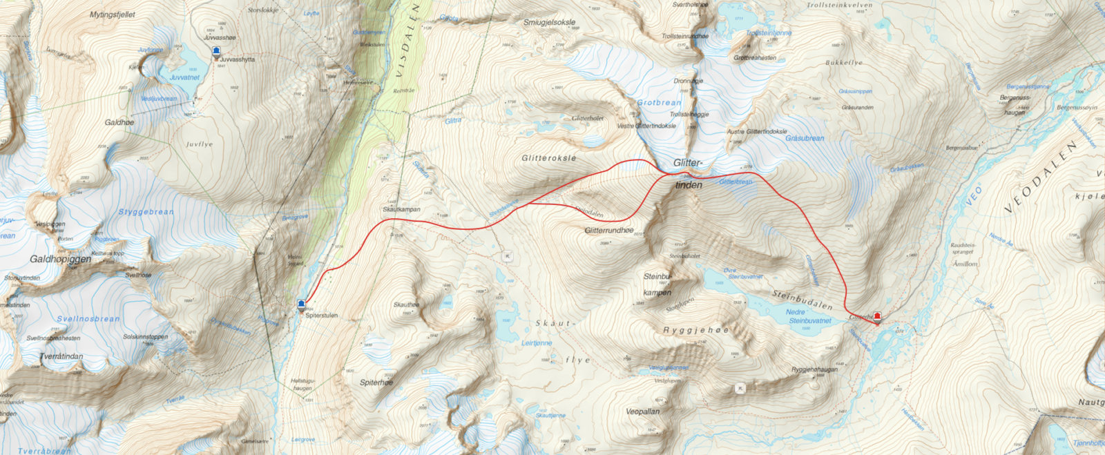
, the height before Galdhøpiggen mountain.3:It is wise to check the map when the terrain is all white. We are on Svelhosbreen glacier. We decide to scrap the original plan and take the easy way out, directly westward.4:Dave looks down at Nordre Illåbrean glacier. We follow the river Illåe down to Leirdalen valley. Then we are not far from Leirvassbu lodge.5:Christina standing on the edge.

Day #5

Leirvassbu > Krossbu

12 Km – 1150 Vertical meters
Open map on ut.no Route selection must be varied according to weather and lead

Ascension of Storebjørn mountain following the ordinary route from the east, thereafter through Bjørnskaret and down onto Leirbrean glacier and down to the Krossbu lodge. In case of bad weather, the trip is completed down Leirdalen valley.

The choice of route must be varied depending on weather and snow conditions, physical condition and ambitions. The trip is not for beginners. Always think safety first. When we took this route last year, the weather was too poor for us to complete the final leg. We also had bad weather on day 4 and chose a route based on the snow conditions. We look forward to testing more alternatives. Jotunheimen Haute Route will be attempted when the sun is shining in April 2014. Perhaps we will see you there?

Krossbu lodge: The lodge is located at the foot of Sognefjellet mountain, right next to Sognefjellsvegen mountain pass road, and is an excellent starting point for randonée ski tours in the area around Smørstabbrean glacier. Alternative routes go to Fannaråken mountain and down Utladalen valley to Upper Årdal village. Krossbu has 75 beds and is staffed in the weeks around Easter.

Opening dates 2024
Winter season: 22 March - middle of September

Read more about Krossbu lodge here